About Aras UNESCO Global Geopark

Aras Geopark
Aras Geopark is located in eastern Azerbaijan Province of Iran. The Geopark has an area of about 1670 square kilometers and spread across the whole Jolfa county.
From a natural geographical view, this mountainous area is the southern end of little Caucasus that encompasses countries include Armenia, Nakhchivan Autonomous Republic and northern Azerbaijan of Iran. This mountain alongside with Alborz and Zagros are forming middle part of Alpine-Himalayan Orogeny that stretches from southern Europe to eastern Asia and acting as a natural barrier, caused a great diversity in climate, life and cultures in each two sides slopes.
The main source of precipitations is the Mediterranean wet air fronts which enter the area on early autumn to mid-spring from northwest and west, and forms an average precipitation about 250-350 mm per year.
The topography is generally extremely steep, and forms astonishing landscapes, so that the highest point in Jolfa region is the Kiyamaki mount with 3347 m and the lowest points include the northern boundary and the Aras river valley with 720 to 390 meters. Given to its climate, the area has a diverse vegetation, so that Aras valley is covered by subtropical trees, since the western and middle parts are dominated by steppe, and Arasbaran dense forests are seen on eastern slopes. The permanent snow line is located above the altitude of 3000 meters.
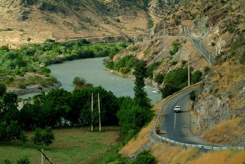
The main river in the area is the Aras river that make the northern boundary of the geopark with Armenia and Nakhchivan Autonomous Republic. The continues roaring steam of the river passing from northwestern to northeastern drains surface waters in the area. The river in downstream meets the Kura River and at last flows into the Caspian Sea.
The area has an appropriate geo-tourism attraction, because of its mountainous landscapes, and outcropping different sedimentary and igneous rocks, diversity in tectonic structures, semi-cold and semi-arid climate and diverse flora and fauna.
Main geosites in the Geopark include Kamtal, Marakan, Darediz and Kiyamaki localities, that given to their diverse flora and fauna, are protected by Iranian Department of Environment. Among the most notable geological features of the Geopark can mention to Paleozoic-Mesozoic sedimentary rocks sequence, especially the conformity of Permian to Triassic sediments, that is very interesting for geologists, plutonic provinces and extensive granitic rocks which is covered eastern part of area, volcanic and sub-volcanic provinces that form Kiyamaki dome, compression regime resulting from Alpine Orogeny which causes developing different structural features such as faulting, trusting and folding of rocks, fossil site localities, mineral springs which deposit travertine, and at last the Aras River and its related geomorphic features. Each of these phenomena can shows different orogenic phases, its forming processes and life history on our planet.
Geologically, Iranian Plateau can be divided into some geological zones. Each of these zones has a different history. Knowing that each area belong to what zone, can help us to detecting geological events in the past. Main geological zones in Iran are Kopet-dag, Central Iran and Zagros, and Aras Geopark is located in Central Iran.
From a structural geology point of view, the Geopark is a fold and thrust system and thrust faults (a reverse fault with low dip) and folded structures are dominant tectonic structures in the area. The predominant fold’s trend is east-west to northwest-southeast, which is coincident with regional scale fold’s trend.
Central Iran Zone is micro-continent between Zagros Zone in the south and Kopet-dag in the north, and stretched beyond the eastern and western Iranian borders. This micro-continent itself, is a part of micro-continental belt named Cimmeria extended form Turkey to China. The micro-continent Cimmeria was a part of super-continent Gondwana in the southern hemisphere near the Equator until late Paleozoic and early Permian (about 300 Ma). In that time, with intra-continent rifting caused by convection currents in mantle, the micro-continent separated from Gondwanaland, and moved toward super-continent Laurasia in the north. In the Late Triassic Period, the micro-continent Cimmeria collide with super-continent Laurasia, leading to folding seabed sedimentary layers and uplifting the area. Since then, continues compression has resulted in folding and thrusting in the area.
Aras Geopark has significant geological and geomorphological features, including extended outcrops of well-bedded sedimentary rocks with distinctive colors, Middle Paleozoic to Early Mesozoic rich fossil beds, Cretaceous and Eocene clastic deposits, Eocene and Miocene red clastic sediments, and Oligocene intrusive and extrusive igneous rock.
In the Geopark, sedimentary rock outcrops are dominant, and the oldest sedimentary rocks date to 400 Ma, namely Devonian Period. Paleozoic to Mesozoic Limestone has deposited in a vast platform basin with low tectonic activities, leading to Jeirood formation Devonian limestone and dolostone, Dorood formation sandstone and Ruteh limestone date to Permian Period, and Elika formatin Triassic limestone and dolostone. Flysch deposits are extended well too in the area. These deposits resulted from depositing alternate sandstone and shale in the deep marine basins, near a continental active orogeny. In these basins, with progressing the orogeny, erosion exacerbates, which lead to transporting a huge mass of sediments, from sand to mud, into the sea, via rivers and deposit in deep marine basin. Outcropping Miocene clastic deposits with massive conglomerate, red sandstone and green marl, formed amazing landscapes from colored slopes. These landscapes usually are seen around Siahrood and Eiry village in the Geopark. These sedimentary rocks often contain fossil, forming a diverse assemblage of brachiopods, pelecypoda, ammonites, echinoids and corals. Placing plutons in the eastern part of Geopark, around Ushtabin and Kordasht villages and volcanic eruptions date to Oligocene, plays and important role in forming the Geopark topography and its highlands.

